In order to understand California’s climate, the natural cycles that govern the state must be investigated. Californian climate is dependent on several main cycles: the seasonal cycle, multiple climate variability cycles, and the hydrological cycle. In collaboration these produce a temperate climate and allows California to bolster the 5th largest economy in the world.
The seasonal cycle consists of shifts from summer to winter weather. An imbalance in the solar heating of the Earth, due to the 23-degree tilt in its orbital axis, creates a temperature difference between the northern and southern hemispheres and between the equator and the poles. These differences, and the rotation of the Earth, results in massive, stable atmospheric currents. The most important of these for California are the Hadley and Walker circulations (Figure 1).
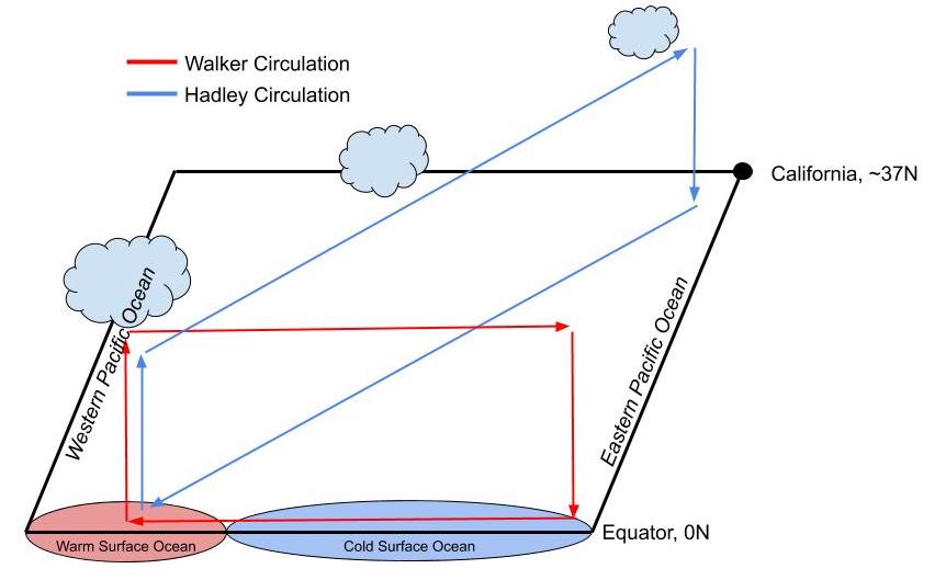
On average, the Hadley circulation moves warm, tropical air from the equator towards the tropics, carrying tropical storms with it. This explains why the largest storm systems that reach California come from the south. The Walker circulation cycles air east and west along the equator. The natural variation in the strength of this circulation influences the intensity of these tropical storms and is an integral component of the climate variability cycles.
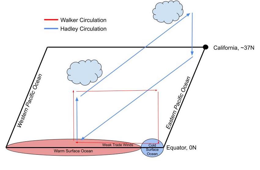
The ENSO, or El Niño-Southern Oscillation, is the most important climate variability cycle and it gives us insight into the intensity of the storms that the Hadley circulation brings to California. At its core, the ENSO represents several physical properties, such as sea surface temperature and wind velocity, which interact to create somewhat recognizable patterns of climate in the Pacific Ocean and can significantly influence global climate [1,2]. The sea surface temperature of the equatorial Pacific is strongly correlated to the amount of rain that central and southern California receives [3,4]. This temperature is also physically correlated with the strength of the wind generated in the Walker circulation, known as the trade winds [2]. Weak trade winds are correlated to an increase in the area of warm surface ocean along the equator, which reduces the distance tropical storms must travel in order to reach California, resulting in El Niño conditions and more rain than normal (Figure 2).
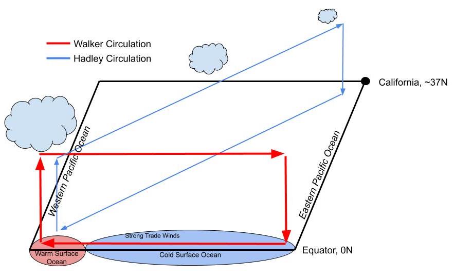
The opposite also occurs with strong trade winds, which result in a decrease in the area of warm surface ocean and an increase in the distance storms must travel to reach California. This produces La Niña conditions and less rain than normal (Figure 3).
NOAA classifies an event as an El Niño or La Niña when the temperature of the equatorial Pacific is half of a degree Celsius above or below normal, respectively, and ‘persist for five consecutive overlapping three-month periods.’ The further and longer the temperature deviates from this threshold, the more intense these events become. Years not classified as Niño or Niña are neutral or transitionary, and the conditions reflect dampened Niña conditions. Many more factors, including other climate variability cycles, like the Pacific Decadal Oscillation, influence the the ENSO making it incredibly complex to make accurate predictions for the condition of the ENSO in any given year. The more long-term a prediction is, the less accurate the prediction is, making it difficult to forecast changes to the ENSO due to climate change.
Rising global temperature, due to anthropogenic fossil fuel emissions, will have an effect on the equatorial Pacific Ocean, although the scientific community is still trying to understand how the Hadley [5] and Walker circulations will be impacted [6,7,8]. Intuition points to the theory that the area of warm surface ocean along the equatorial Pacific will increase, Walker circulation will weaken, and Niño events will likely be either prolonged or more intense, and as such, deliver more wintertime rain than usual [7,8]. Of course there are other factors influencing California precipitation, like sub-tropical jet streams, mid-latitude cyclones and accelerating mid-latitude prevailing winds, all indicating a weak trend towards wetter winters [9]. There will still be natural variation in the equatorial Pacific, so Niña events will likely still occur, although less frequently. Swinging between seasonal extremes, further amplified by climate variability, sets up many environmental hazards for the Golden State.
The combination of the seasonal cycle and the climate variability cycles creates a ‘Mediterranean climate’ in California, where rain and cool weather are expected in the winter and hot, dry summers follow [9]. This flip from season to season establishes a unique hydrological cycle for California and other Mediterranean climates. The hydrological cycle is particularly special in California, in part because much of the annual rain falls as snow. Sierra Nevada (SN) snowpacks host between a 1/3 and 2/3 of the freshwater in California in any given year [10]. The SN snowpack conveniently stores this water in the winter and spring, gradually releasing it for us as mountain temperatures rise in the summer and fall. Thus, regional temperatures in the SN mountains directly impact this storage and release of freshwater throughout the year. Changes to precipitation patterns and increasing temperatures in the SN mountains has significant implications for how California stores and manages water resources in Niño (wet) and Niña (dry) conditions alike.
References:
- Philander, S. G. H. (1983). El Niño Southern Oscillation phenomena. Nature, 302(5906), 295–301. https://doi.org/10.1038/302295a0
- Santoso, A., Mcphaden, M. J., & Cai, W. (2017). The Defining Characteristics of ENSO Extremes and the Strong 2015/2016 El Niño: ENSO Extremes. Reviews of Geophysics, 55(4), 1079–1129. https://doi.org/10.1002/2017RG000560
- Schonher, T., & Nicholson, S. E. (1989). The Relationship between California Rainfall and ENSO Events. Journal of Climate, 2(11), 1258–1269. <a href=”https://doi.org/10.1175/1520-0442(1989)002https://doi.org/10.1175/1520-0442(1989)002<1258:TRBCRA>2.0.CO;2
- Patricola, C. M., O’Brien, J. P., Risser, M. D., Rhoades, A. M., O’Brien, T. A., Ullrich, P. A., et al. (2020). Maximizing ENSO as a source of western US hydroclimate predictability. Climate Dynamics, 54(1–2), 351–372. https://doi.org/10.1007/s00382-019-05004-8
- Kang, S. M., Deser, C., & Polvani, L. M. (2013). Uncertainty in Climate Change Projections of the Hadley Circulation: The Role of Internal Variability. Journal of Climate, 26(19), 7541–7554. https://doi.org/10.1175/JCLI-D-12-00788.1
- Power, S. B., & Smith, I. N. (2007). Weakening of the Walker Circulation and apparent dominance of El Niño both reach record levels, but has ENSO really changed? Geophysical Research Letters, 34(18), L18702. https://doi.org/10.1029/2007GL030854
- Collins, M., An, S.-I., Cai, W., Ganachaud, A., Guilyardi, E., Jin, F.-F., et al. (2010). The impact of global warming on the tropical Pacific Ocean and El Niño. Nature Geoscience, 3(6), 391–397. https://doi.org/10.1038/ngeo868
- Power, S. B., & Kociuba, G. (2011). What Caused the Observed Twentieth-Century Weakening of the Walker Circulation? Journal of Climate, 24(24), 6501–6514. https://doi.org/10.1175/2011JCLI4101.1
- Polade, S. D., Gershunov, A., Cayan, D. R., Dettinger, M. D., & Pierce, D. W. (2017). Precipitation in a warming world: Assessing projected hydro-climate changes in California and other Mediterranean climate regions. Scientific Reports, 7(1), 10783. https://doi.org/10.1038/s41598-017-11285-y
- Lundquist, J. D., Hughes, M., Henn, B., Gutmann, E. D., Livneh, B., Dozier, J., & Neiman, P. (2015). High-Elevation Precipitation Patterns: Using Snow Measurements to Assess Daily Gridded Datasets across the Sierra Nevada, California*. Journal of Hydrometeorology, 16(4), 1773–1792. https://doi.org/10.1175/JHM-D-15-0019.1
